How I made the map of the buildings of Reykjavík
Maps
Every dataset is messy, and each is messy in its own way
We don’t live in a perfect world full of perfect things, but we can try to. Data fits this model: it’s never flawless, but we constantly strive to make it better.
The underlying data that makes up my map of Reykjavík’s buildings by construction date comes from three sources: shapes and names of buildings are provided by OpenStreetMap; locations of land plots come from Þjóðskrá’s Staðfangaskrá dataset; and building construction dates come from Þjóðskrá’s Fasteignaskrá.
Combining datasets is always problematic as they’re often created in isolation without interoperability being a priority. You might see such problems hiding in the data sources above: OpenStreetMap has building shapes but no addresses, Þjóðskrá has one dataset with x and y coordinates for land plots but not buildings, and another with construction dates for properties (apartments etc) but not buildings. Joining these up is complicated.
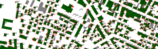
The map in a more raw form, before it was beautified.
While the vast majority of data on the map is accurate some errors have inevitably sneaked in. If you see an error in the names or building shapes, correct them on OpenStreetMap. And if you have a moment, ask Þjóðskrá to provide all building metadata as open data. Þjóðskrá have locations, construction dates, property values, and much more for every single free-standing building, apartment, and bike shed in Iceland; wouldn’t it be wonderful if that was open source?
I can also make corrections to the map directly. If you see anything you think is wrong, please contact me. If it’s a genuine error I’ll make a correction and note it here.
Contributed corrections
- 16 September 2013: Vesturbæjarskóli was marked as having being built in 1934 (the date of the oldest building on campus) but the main building was built in 1989. The later dates makes more sense. Thanks to Gylfi Magnússon.
- 17 September 2013: Hellusund 7 and Grundarstígur 23 were incorrectly marked as one building. Fixed both here and on OpenStreetMap. Thanks to Ólöf Björk.
- 17 September 2013: Harpa was incorrectly named Íslenska Óperan. Fixed both here and on OpenStreetMap. Thanks to Hilmar Sigurðsson.
- 17 September 2013: Vallagerði 8 in Kópavogur was missing. Thanks to Garðar Pétursson.
- 17 September 2013: Tjarnargötu 3c was built in 1880 but was moved to Grjótagötu 11 in 1990. Þjóðskrá uses the more recent date for the year of construction but it seems to me that it’s more accurate to use 1880. Thanks to Ari Egilsson.
- 18 September 2013: Brekkustígur 6 and 4a, Vesturbæjar, were missing. Thanks to Þráinn Sigurjónsson.
- 19 September 2013: the buildings on the east side of Austurvöllur were shown as one building from 1959 when in fact there are three, built in 1918, 1929, and 1959. Fixed both here and on OpenStreetMap. Thanks to Linus.
- 19 September 2013: Ingunnarskóli and Leikskólinn Mariúborg were dated incorrectly. Thanks to Ívar Kjartansson.
- 27 January 2014: The Kópavogur suburbs of Þing, Vatnsendi, and Hvörf, all on the banks of Elliðavatn, were missing. Thanks to Brian Suda for pointing it out.
Weepy acceptance speech
Thanks to Þorlákur Lúðvíksson for help with the design process and Páll Hilmarsson for pointing me towards the data.